Wildfires are spreading across more places, burning more land, and leaving less time to respond. Now satellites, artificial intelligence, aircraft, and ground cameras are joining the fight to find flames before they become disasters.
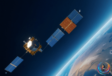
The first three FireSat satellites reached orbit on a SpaceX rocket in July 2026, opening a new chapter in wildfire detection. The planned network of 50 satellites is designed to detect fires as small as a beach bonfire and scan every point on Earth about every 20 minutes once the full constellation is deployed.
FireSat Brings AI Into the Earliest Moments
FireSat satellites use infrared sensors and artificial intelligence to search for heat that could signal a new wildfire. The system compares fresh images with earlier images, then accounts for weather conditions and nearby heat sources before sending alerts.
That process targets a major weakness in existing systems. Weather and Earth-observing satellites can detect large fires, but they often lack the resolution or revisit frequency needed to spot small fires soon after ignition. FireSat is designed to close that gap from orbit, giving emergency teams a better chance to act before a fire races across the landscape.
Ground-based cameras are adding another layer of coverage. Pano AI has installed more than 1,400 cameras across 17 states in the United States, where the systems scan landscapes for smoke during the day and heat after dark. AI algorithms review the imagery and identify potential fires, with the review and alert process often taking only a few minutes.
“The AI algorithms are being run continuously on that imagery to say ‘smoke, not smoke,’” said Arvind Satyam, co-founder of Pano AI. California has built its own network of more than 1,200 cameras used by Cal Fire, creating a dense watch system in one of the regions hit hardest by wildfire.
For firefighters, earlier warning can change the entire response. “Having those eyes that can alert us well in advance of potentially a 911 call make it a valuable tool for us,” said Brendan Finnegan, assistant chief with West Metro fire rescue.
A Global Fire Season Is Stretching Systems
The need for faster detection is clear. Wildfires have scorched more than 370 million acres across 80 countries in 2026, with fires tearing through the savannahs of sub-Saharan Africa, the rainforests of South America, and resorts on France’s Atlantic coast.
- Canada endured its largest wildfire season on record, with between four and six million hectares burned.
- Europe lost more than 550,000 hectares, with estimated costs between €15.6 billion (£13 billion) and €19.1 billion (£16.4 billion).
- More than 300,000 people were evacuated across Spain and France, while nearly 10,000 members of Canada’s First Nations indigenous community were displaced.
- California recorded more than 4,000 fires by May 2026, burning nearly a quarter of a million acres.
- Africa accounted for 46% of all global blazes since May 2026, with more than 191,000 wildfires reported.
- Australia recorded nearly 21,000 wildfires by August 2026, with at least five people killed during bushfire season.
- Chile’s January 2026 fires killed 21 people and burned 45,000 hectares.
Fire intensity also varies across regions. The mean intensity of a fire in the Democratic Republic of Congo reached 12.1 megawatts, compared with 17.2 megawatts in Canada. As Mark Parrington, a senior scientist at the Copernicus Atmosphere Monitoring Service, put it: “It is not simply about where fires are occurring, but also how extreme those fires are becoming.”
The human cost extends far beyond the burned area. A 2024 Lancet study recorded more than 1.5 million deaths each year from smoke inhalation caused by landscape fires, while Technosylva estimated that approximately 150 million acres have burned worldwide.
The UK Shows Why Minutes Matter
The United Kingdom is facing the same pressure. More than 1,017 wildfires have raged across the country in 2026, matching last year’s record-breaking total, with 458 fires recorded in July alone. Between January 1 and August 12 in 2025, the UK recorded 869 wildfires; during the same period in 2024, it recorded 843.
Several major incidents have put that rising figure into focus. A fire began in Cairngorms National Park on 15 July 2026, another started in Suffolk on 29 July, and a wildfire struck Beacon Heath in Devon on 1 August. A Suffolk wildfire incident stood down on 7 August, while a major incident declared in the Peak District on 12 July was stood down by early August.
At Tintwistle Moor in the Peak District, more than 1,400 acres burned in August. In the New Forest, a wildfire spread across more than 1.6 square kilometers from 9 August 2026. The Met Office has also warned that a heatwave could be on the horizon in September.
Europe’s fire map is changing, with significant activity expanding into regions that have historically experienced less wildfire. France faced an “extreme wildfire year” in 2026, including large fires threatening Bordeaux and evacuations. One French fire grew from 80 hectares on Friday to nearly 3,000 hectares on Sunday after burning since Thursday, while Portugal’s Vouzela-Agueda region saw more than 13,000 hectares burned, including 8,744 buildings.
Greece experienced fires that overwhelmed the country, and an estimated 20 buildings were torn through by fires in Los Gallardos, Spain. Wildfires were also reported in Japan, Turkey, Indonesia, and Chile, while South Korea reached 42C during summer 2026, causing underground potatoes to boil. Canada recorded its highest Ontario wildfire emissions since 2003 during a five-day period.
“We have an opportunity now to try and mitigate and prevent wildfires happening rather than just responding to them,” said Dr Ford. She also warned, “More hot and dry conditions mean we are likely going to get wildfires. That’s the trend we’re going towards.”
FireSat will not replace firefighters, cameras, aircraft, or local decisions. It can give them a clearer view of what starts burning, where the heat is changing, and how quickly a threat may grow. As Dr Theodore Keeping said, “The worst fire events are worse than they were even a relatively short period ago.” The race now is to make detection move faster than the flames.
Based on
- AI eyes in the sky: new satellites and artificial intelligence are transforming wildfire detection — theguardian.com
- The world is on fire: True scale of devastating wildfires wreaking havoc across the globe | The Independent — independent.co.uk
- Europe wildfires: latest developments | AFP.com — www-pp.afp.com
- Colorado aerial fire spotters detect record number of lightning-caused wildfire starts in July – CBS Colorado — cbsnews.com
- Mapped: The wildfires scorching the UK as four major incidents still ongoing | The Independent — independent.co.uk